CROSSING OF SUPRAMONTE
BOOK NOWCrossing of Supramonte
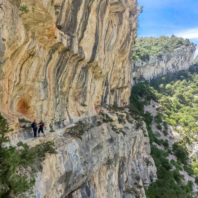
The Crossing of Supramonte is a four days walk which crosses the mountains at the heart of Sardinia. It runs for 50 km in total, from the Arcu Correboi to the spring Su Gologone. The walk is never hard and every night is spent on a different mountain refuge.
Walking the Great Trail the Supramonte offers a unique chance to view and experience a different Sardinia. Walking on green plateaus and on the crest of mountains, we’ll be drinking water at the very spring of rivers and eating simple and delicious local food. Each night will be spent on typical and ancient shepherds' huts. The trek includes visits to ancient and mysterious Nuraghe and the famous chasm Su Sercone.
How do we run the Crossing of Supramonte
Our tours are planned to reduce any possible risk, led by professional guides and supported by meticulous logistic support. The group meets in Oliena on the day of departure, and our team drives it to the starting point (50 minutes drive). The tour ends 3 days later, around 4 pm when our team will meet the group and drive it back to Oliena (15 minutes drive).
- Arriving: We expect all participants to be in Oliena at 9 am. Our team drives the group and the guide to the starting point.
- Food: We provide all food (breakfast, packed lunch and dinner). Please tell us about any intolerances or allergies ahead. We fix breakfast and dinner on the spot and take care of all waste.
- Water: there are many fountains along the itinerary where it is possible to fill your bottles
- Accommodation: each of the 3 nights is spent in unattended huts. You can choose to have your tent instead.
- Sleeping: you must have your sleeping bag and inflatable mat. A tent is optional.
- Facilities: there are NO facilities at all. This is a trek on a wild mountain region.
hide
FIRST DAY
Highlights: From the centre of Oliena the group is driven to starting point . The path immediately finds the spring of the Flumineddu river, which ends on the famous gorge Gorroppu. Passing mount Fumai and other bare peaks the day ends on a wooden refuge located at the top of Montenovo San Giovanni.
Starting: Arcu Correboi (1246 m asl)
Length: 8 km
Gain: 470 m
Time: 6 h
Ending: Montenovo S. Giovanni (1316 m asl)
SECOND DAY
Highlights: the second day reveals ancient huts, forests and rivers hidden in Supramonte. The day ends at the renovated hut Ziu Raffaele on the Campu Donianicoro. The hut is very wide and a close spring offers drinkable water.
Starting: Montenovo San Giovanni (1316m asl)
Length: 13 km
Gain: 360 m
Time: 8 h
End: Sedda ‘ar baccas (770 m slm)
THIRD DAY
Highlights: the third day is spent walking in ancient oak forests and on the crest of mountains. We’ll be passing by the chasm Su Sercone and ending on a plateau where the hut Cuile Pradu lays.
Starting: Sedda ‘ar baccas (770 m slm)
Length: 8 km
Gain: 640 m
Time: 7 h
Ending: Punta Solitta Pradu (1200 m asl)
FOURTH DAY
Highlights: the last day’s trek passes by the cave Nurra Sas Palumbas, mount Cusidore (1147 m) and the cave Orgo. It ends walking on top of the mounts Fruncu Nieddu and Uddé, ending at the spring Su Gologone. A transfer takes the group back to Oliena.
Starting: Punta Solitta (1200m asl)
Length: 6 km
Gain: 235 m
Time: 6 h
Ending: Iscala ‘e Pradu (1200 m asl)


Crossing of Supramonte
€ 650
Meeting location: Oliena
Meeting time: 9:00 am
Estimated return: 4 days later, 6:30 pm approx
DETAILS
Total length: 48 km
Total timing: 4 days
Difficulty: medium
hide
What is included?
- Walking four days lead by Professional mountain guide
- Transfer to the starting point and pick-up from arrival point
- Breakfast, packed lunch and dinner.
- Water is naturally available along the trekking
Should I carry my own food?
The basic package of this tour does not include food and drinks. Each participant must be independent.
This trekking can represent a great lesson in dietary needs to those who are not used to spending more than one day outdoor. Each participant must reduce and optimize one’s own necessities, and in some cases even challenge her/himself
Water can be collected along the trekking. We will pass by many natural springs and rivers. Those who do not trust natural springs should have a portable filter.
What do I need?
- Backpack, at least 50 litres
- Winter sleeping bag
- Inflatable mat
- Tent (Optional)
- Water bottle 2 litres
- Headlight and spare batteries
- Enough food for the whole tour
- Gas burner, gas, stoves, cutlery and plates
- Comfortable clothes
- Boots or hiking shoes with a hard sole
How difficult is the Crossing of Gennargentu?
The trekking starts at an altitude of 1250 meters above sea level and will keep a similar altitude in the days to come. The path is easy and there are no major uphills or scree. On the last day of walking the path includes some hopping on rocks to descend to the end point, this anyhow can be skipped by passing on a lower track.
It is fundamental not to have irrational fears such as acrophobia or agoraphobia, and be ready for a challenge and get tired.
Will we find any water springs along the itinerary?
We will pass by some natural springs, a river and hidden caves.
We recommend always bringing a portable water filter.
From May to November there may not be water. In this case we will have to organize a water drop-off along the itinerary. We will also need to pack food that doesn’t need much water to be prepared.
Water shortage will also prevent us from using pots and dishes. We shall contain all wastes and eat meals that don’t require much cleaning.
What should I wear?
In the summertime, it is best to wear a polyester t-shirt and shorts. Cotton shirts get wet and won’t dry out in time. The trekking lasts almost 5 hours trek (including return).
We recommend a soft-shell jacket as it is often windy.